#!pip install pytrends
from pytrends.request import TrendReq
import pandas as pd
import numpy as np
import matplotlib.pyplot as plt
import matplotlib
from IPython.display import Imagehttp://open-notify.org/Open-Notify-API/ISS-Location-Now/
The ISS programme is a joint project between five participating space agencies: NASA (United States), Roscosmos (Russia), JAXA (Japan), ESA (Europe), and CSA (Canada). The ownership and use of the space station is established by intergovernmental treaties and agreements.
The ISS serves as a microgravity and space environment research laboratory in which crew members conduct experiments in biology, physics, astronomy, and other fields.
This is all from Wikipedia.
GO TO: http://open-notify.org/
# Who is in space right now?
import requests
r = requests.get(url='http://api.open-notify.org/astros.json')
t=r.json()
print(t)
print(t['number'])
print(t['people'][0]['name'])
print(t['people'][1]['name'])
print(t['people'][2]['name'])
{'number': 3, 'people': [{'craft': 'ISS', 'name': 'Chris Cassidy'}, {'craft': 'ISS', 'name': 'Anatoly Ivanishin'}, {'craft': 'ISS', 'name': 'Ivan Vagner'}], 'message': 'success'}
3
Chris Cassidy
Anatoly Ivanishin
Ivan Vagner
    r = requests.get(url='http://api.open-notify.org/astros.json')
    point=r.json()
    number=point['number']
    print(number)
    astro=[]
    for i in range(0,number):
        astro.append(point['people'][i]['name'])
    print(astro)
3
['Chris Cassidy', 'Anatoly Ivanishin', 'Ivan Vagner']
r = requests.get(url='http://api.open-notify.org/iss-now.json')
space_station_location = (r.json())
print(space_station_location)

space_station_location['iss_position']['latitude']
space_station_location['iss_position']['longitude']
space_station_location['timestamp']
{'timestamp': 1598432463, 'message': 'success', 'iss_position': {'longitude': '163.7154', 'latitude': '-51.5850'}}
1598432463
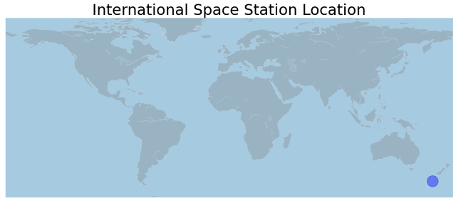
# let's plot the ISS current location
# you will need to pip install Basemap - https://matplotlib.org/basemap/users/installing.html
#!sudo apt-get install libgeos-3.5.0
#!sudo apt-get install libgeos-dev
#!sudo pip install https://github.com/matplotlib/basemap/archive/master.zip
from mpl_toolkits.basemap import Basemap

# Set the dimension of the figure
plt.figure(figsize=(16, 8))

# Make the background map
m=Basemap(llcrnrlon=-180, llcrnrlat=-65,urcrnrlon=180,urcrnrlat=80)
m.drawmapboundary(fill_color='#A6CAE0', linewidth=0)
m.fillcontinents(color='grey', alpha=0.3)
m.drawcoastlines(linewidth=0.1, color="white")


m.scatter(float(space_station_location['iss_position']['longitude']),
          float(space_station_location['iss_position']['latitude']),
          s=500, alpha=0.4,color='blue')


plt.title('International Space Station Location' , fontsize=30)
Text(0.5, 1.0, 'International Space Station Location')
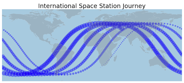
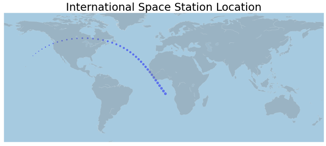
We know that it orbits 15.5 perday, so let it run at least 2 hours to collect enough data to see it go around the earth once.
record_data = True
if record_data == True:
    import datetime
    date_to_print = datetime.datetime.now().strftime("%Y%m%d%H%M%S")

    import time
    starttime=time.time()


    space_station_data = []
    while True:
        r = requests.get(url='http://api.open-notify.org/iss-now.json')
        space_station_location = (r.json())
        print(space_station_location)

        space_station_data.append([space_station_location['timestamp'],
                                space_station_location['iss_position']['latitude'],
                                space_station_location['iss_position']['longitude']
                                ])

        # dump copy to file
        tmp_space_station_data_df = pd.DataFrame(space_station_data, columns=['timestamp','latitude', 'longitude',])
        tmp_space_station_data_df.to_csv('ISS_location_' + date_to_print + '.csv', index=None)

        # safety break
        if len(space_station_data) > 600:
            break

        # let it sleep 60 seconds
        # https://stackoverflow.com/questions/474528/what-is-the-best-way-to-repeatedly-execute-a-function-every-x-seconds-in-python
        time.sleep(60.0 - ((time.time() - starttime) % 60.0))
{'timestamp': 1598278430, 'iss_position': {'longitude': '-147.3252', 'latitude': '31.8861'}, 'message': 'success'}
{'timestamp': 1598278490, 'iss_position': {'longitude': '-144.1312', 'latitude': '34.4923'}, 'message': 'success'}
{'timestamp': 1598278550, 'iss_position': {'longitude': '-140.7481', 'latitude': '36.9754'}, 'message': 'success'}
{'timestamp': 1598278610, 'iss_position': {'longitude': '-137.0943', 'latitude': '39.3597'}, 'message': 'success'}
{'timestamp': 1598278670, 'iss_position': {'longitude': '-133.1724', 'latitude': '41.6044'}, 'message': 'success'}
{'timestamp': 1598278730, 'iss_position': {'longitude': '-128.9606', 'latitude': '43.6874'}, 'message': 'success'}
{'timestamp': 1598278790, 'iss_position': {'longitude': '-124.4422', 'latitude': '45.5845'}, 'message': 'success'}
{'timestamp': 1598278850, 'iss_position': {'longitude': '-119.6505', 'latitude': '47.2565'}, 'message': 'success'}
{'timestamp': 1598278910, 'iss_position': {'longitude': '-114.5098', 'latitude': '48.7045'}, 'message': 'success'}
{'timestamp': 1598278970, 'iss_position': {'longitude': '-109.0806', 'latitude': '49.8865'}, 'message': 'success'}
{'timestamp': 1598279030, 'iss_position': {'longitude': '-103.4021', 'latitude': '50.7779'}, 'message': 'success'}
{'timestamp': 1598279090, 'iss_position': {'longitude': '-97.5833', 'latitude': '51.3545'}, 'message': 'success'}
{'timestamp': 1598279150, 'iss_position': {'longitude': '-91.6029', 'latitude': '51.6116'}, 'message': 'success'}
{'timestamp': 1598279210, 'iss_position': {'longitude': '-85.5984', 'latitude': '51.5362'}, 'message': 'success'}
{'timestamp': 1598279270, 'iss_position': {'longitude': '-79.6595', 'latitude': '51.1304'}, 'message': 'success'}
{'timestamp': 1598279330, 'iss_position': {'longitude': '-73.9179', 'latitude': '50.4120'}, 'message': 'success'}
{'timestamp': 1598279390, 'iss_position': {'longitude': '-68.3463', 'latitude': '49.3863'}, 'message': 'success'}
{'timestamp': 1598279450, 'iss_position': {'longitude': '-63.0445', 'latitude': '48.0809'}, 'message': 'success'}
{'timestamp': 1598279510, 'iss_position': {'longitude': '-58.0434', 'latitude': '46.5217'}, 'message': 'success'}
{'timestamp': 1598279570, 'iss_position': {'longitude': '-53.3562', 'latitude': '44.7359'}, 'message': 'success'}
{'timestamp': 1598279630, 'iss_position': {'longitude': '-49.0161', 'latitude': '42.7675'}, 'message': 'success'}
{'timestamp': 1598279690, 'iss_position': {'longitude': '-44.9385', 'latitude': '40.6090'}, 'message': 'success'}
{'timestamp': 1598279750, 'iss_position': {'longitude': '-41.1413', 'latitude': '38.2991'}, 'message': 'success'}
{'timestamp': 1598279810, 'iss_position': {'longitude': '-37.6011', 'latitude': '35.8587'}, 'message': 'success'}
{'timestamp': 1598279870, 'iss_position': {'longitude': '-34.2929', 'latitude': '33.3064'}, 'message': 'success'}
{'timestamp': 1598279930, 'iss_position': {'longitude': '-31.2161', 'latitude': '30.6808'}, 'message': 'success'}
{'timestamp': 1598279990, 'iss_position': {'longitude': '-28.2949', 'latitude': '27.9521'}, 'message': 'success'}
{'timestamp': 1598280050, 'iss_position': {'longitude': '-25.5325', 'latitude': '25.1544'}, 'message': 'success'}
{'timestamp': 1598280110, 'iss_position': {'longitude': '-22.9069', 'latitude': '22.2984'}, 'message': 'success'}
{'timestamp': 1598280170, 'iss_position': {'longitude': '-20.4186', 'latitude': '19.4186'}, 'message': 'success'}
{'timestamp': 1598280230, 'iss_position': {'longitude': '-18.0070', 'latitude': '16.4746'}, 'message': 'success'}
{'timestamp': 1598280290, 'iss_position': {'longitude': '-15.6761', 'latitude': '13.4985'}, 'message': 'success'}
{'timestamp': 1598280350, 'iss_position': {'longitude': '-13.4094', 'latitude': '10.4968'}, 'message': 'success'}
{'timestamp': 1598280410, 'iss_position': {'longitude': '-11.1917', 'latitude': '7.4761'}, 'message': 'success'}
{'timestamp': 1598280470, 'iss_position': {'longitude': '-9.0264', 'latitude': '4.4673'}, 'message': 'success'}
{'timestamp': 1598280530, 'iss_position': {'longitude': '-6.8632', 'latitude': '1.4258'}, 'message': 'success'}
{'timestamp': 1598280590, 'iss_position': {'longitude': '-4.7068', 'latitude': '-1.6178'}, 'message': 'success'}
{'timestamp': 1598280650, 'iss_position': {'longitude': '-2.5433', 'latitude': '-4.6583'}, 'message': 'success'}
{'timestamp': 1598280710, 'iss_position': {'longitude': '-0.3776', 'latitude': '-7.6647'}, 'message': 'success'}
{'timestamp': 1598280770, 'iss_position': {'longitude': '1.8407', 'latitude': '-10.6820'}, 'message': 'success'}
---------------------------------------------------------------------------
KeyboardInterrupt Traceback (most recent call last)
<ipython-input-32-d7ba924d2496> in <module>()
29 # let it sleep 60 seconds
30 # https://stackoverflow.com/questions/474528/what-is-the-best-way-to-repeatedly-execute-a-function-every-x-seconds-in-python
---> 31 time.sleep(60.0 - ((time.time() - starttime) % 60.0))
KeyboardInterrupt:
# load historical data
iss_flight_record = pd.read_csv('ISS_location_20200824141350.csv')
# translate timestamp into readable
from datetime import datetime
date_time = [datetime.fromtimestamp(dt) for dt in iss_flight_record['timestamp']]

# add teh date_time to a new column in our data frame iss_flight_record
iss_flight_record['date'] = date_time

# add an plot size from oldest to newest
iss_flight_record['index'] = range(1,len(iss_flight_record)+1)

iss_flight_record.head()
<style scoped>
.dataframe tbody tr th:only-of-type {
vertical-align: middle;
}
</style>
.dataframe tbody tr th {
    vertical-align: top;
}

.dataframe thead th {
    text-align: right;
}
| timestamp | latitude | longitude | date | index | |
|---|---|---|---|---|---|
| 0 | 1598278430 | 31.8861 | -147.3252 | 2020-08-24 14:13:50 | 1 |
| 1 | 1598278490 | 34.4923 | -144.1312 | 2020-08-24 14:14:50 | 2 |
| 2 | 1598278550 | 36.9754 | -140.7481 | 2020-08-24 14:15:50 | 3 |
| 3 | 1598278610 | 39.3597 | -137.0943 | 2020-08-24 14:16:50 | 4 |
| 4 | 1598278670 | 41.6044 | -133.1724 | 2020-08-24 14:17:50 | 5 |
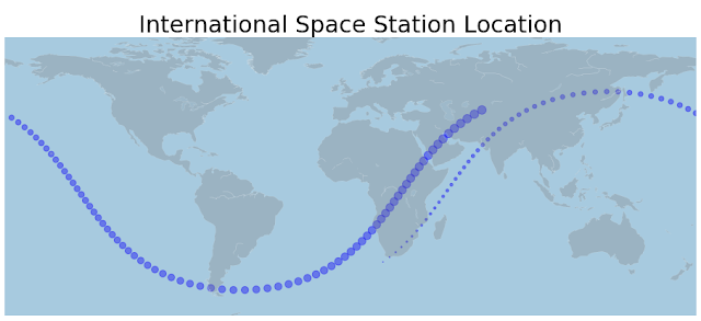
# you will need to pip install Basemap - https://matplotlib.org/basemap/users/installing.html
from mpl_toolkits.basemap import Basemap

# Set the dimension of the figure
plt.figure(figsize=(16, 8))

# Make the background map
m=Basemap(llcrnrlon=-180, llcrnrlat=-65,urcrnrlon=180,urcrnrlat=80)
m.drawmapboundary(fill_color='#A6CAE0', linewidth=0)
m.fillcontinents(color='grey', alpha=0.3)
m.drawcoastlines(linewidth=0.1, color="white")


m.scatter(iss_flight_record['longitude'],
          iss_flight_record['latitude'],
          s=iss_flight_record['index'] , alpha=0.4,color='blue')


plt.title('International Space Station Location' , fontsize=30)
Text(0.5, 1.0, 'International Space Station Location')
